Day 1 Lee's Ferry to Tiger Wash Camp Mile 26.3
I provide sets of photos focused on Grand Canyon geology (as pointed out by Wayne thruout the trip – any errors are mine). Geology is the science that deals with the history of the earth as recorded in rocks so onward to the Day 1 rocks:
I provide sets of photos focused on Grand Canyon geology (as pointed out by Wayne thruout the trip – any errors are mine). Geology is the science that deals with the history of the earth as recorded in rocks so onward to the Day 1 rocks:
At river mile 0 the Shinarump Conglomerate and Moenkopi Formation are visible (they are eroded away later so we need to study/enjoy them now).
The classic Grand Canyon layers are in our future as we board the boats.
At mile 1 the Kaibab Limestone appears.
At mile 1.7 the Toroweap Formation is seen.
After mile 4 we see the Coconino Sandstone which will stay above river level for the rest of our journey (below looking back up river at Navajo Bridge on left we see the top cliff is Kaibab Limestone, the slope under it is Toroweap Formation, and the bottom cliff is Coconino Sandstone).
Note the crossbedding in the Coconino seen at bottom of picture
After mile 5 we see the Hermit Shale appear on river left (red at bottom of picture)
Mile 7.9 Looking Back at Badger Rapid
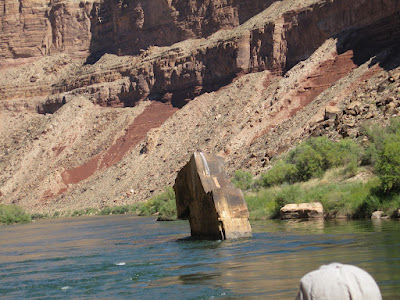
Mile 10 - Ten Mile rock is a large block of Coconino Sandstone that fell from the cliffs above the Supai
Mile 11.2 Looking Back At Soap Creek Rapid
Mile 11.4 Supai Appears
Mile 11.4 Supai Group
Mile 12 Brown Inscription
Mile 14.5 Tanner Wash enters on river left and forms Sheer Wall Rapid

Mile 17 House Rock Rapid - first real rapid on the river
Mile 18.6 Looking back at Boulder Narrows
The Redwall Limestone is seen at mile 23 – this forms the 500-to-700 foot cliffs that restrict rim to river access from now on - the rock spire is known as Indian Dick
Mile 24 - Redwall Limestone easily forms caves (mile 24 and mile 25 on both sides of the river)
Mile 25
Mile 26.3 Tiger Wash Camp - redwall caves across the river from our day 1 camp


No comments:
Post a Comment